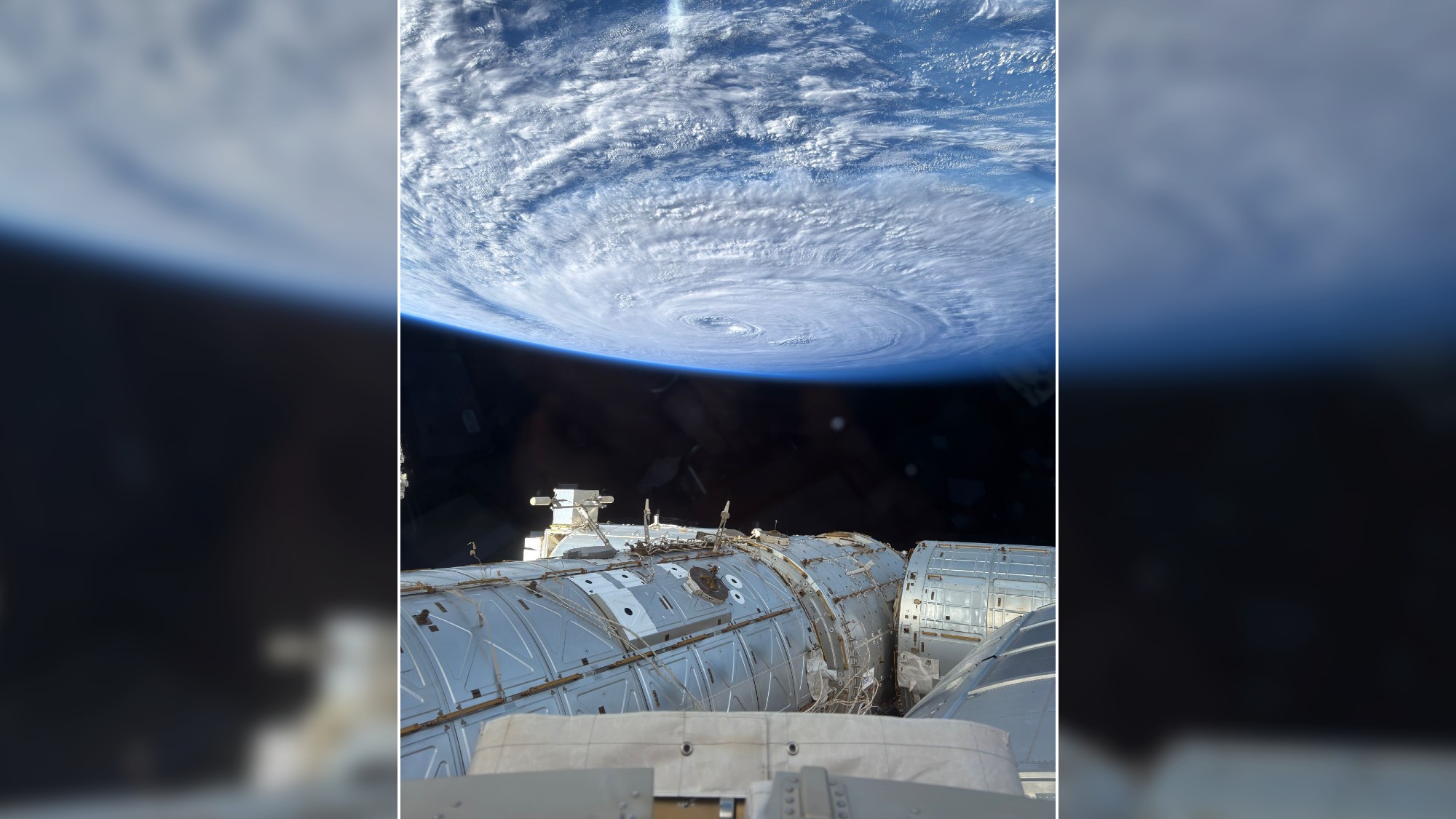
A photograph of a swirling typhoon in the Pacific Ocean taken by NASA astronaut Anil Menon from the cupola of the International Space Station on Aug. 2, 2026. (Image credit: NASA/Anil Menon)
NASA astronaut Anil Menon captured an incredible photograph of a swirling typhoon in the Pacific Ocean from the International Space Station on Aug. 2, 2026.
What is it?
According to his post on X sharing the image, Menon used an iPhone to capture the photo from the space station's cupola, a domed structure built by the European Space Agency that features six circumferential windows and central nadir viewing window.
The photograph shows a massive swirling typhoon in the Pacific Ocean. While Menon doesn't mention the storm or its location by name, it appears to be Super Typhoon Dolphin, the fifth tropical cyclone to reach category 5 in 2026. It has since been downgraded to a category 3 storm, and is expected to weaken to a category 1 or 2 as it continues to move westward towards Japan's Okinawa island.
Why is it incredible?
Aside from being a reminder of how powerful some storms on Earth can be, Menon's photograph shows just how far astronaut photography has come.
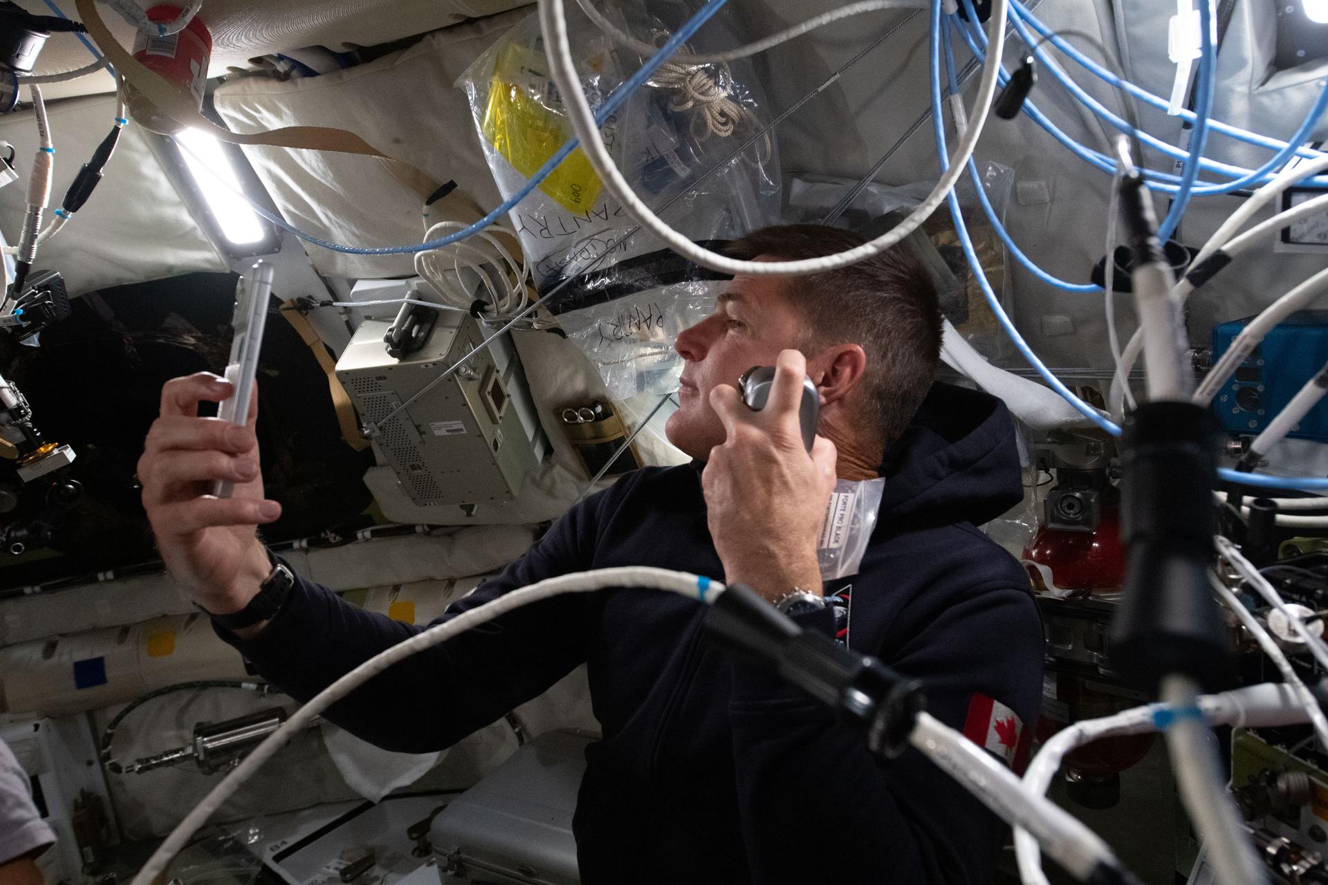
Even equipped with only a phone camera, astronauts can capture breathtaking photos to share with the world. On NASA's recent Artemis II mission around the moon and back, the four crewmembers beamed back incredible images captured with iPhones. They even sometimes used them as "mirrors" while shaving.
Artemis 2 astronaut Jeremy Hansen using a phone as a mirror while shaving before his crew's historic lunar flyby. (Image credit: NASA)
Menon's photo, like other space station photography, also drives home just how mind-boggling of an engineering feat the International Space Station (ISS) truly is.
There are currently seven people aboard the football-field-sized orbital laboratory, circling Earth every 90 minutes at a speed of 17,500 miles per hour (28,000 kilometers/hour) at an average altitude of around 250 miles (400 km).
Since 2000, the ISS has hosted international crews and has been the site of countless groundbreaking scientific experiments made possible by its microgravity environment. But the station is reaching the end of its life; NASA plans to retire it and crash it in into the Pacific Ocean around 2030.
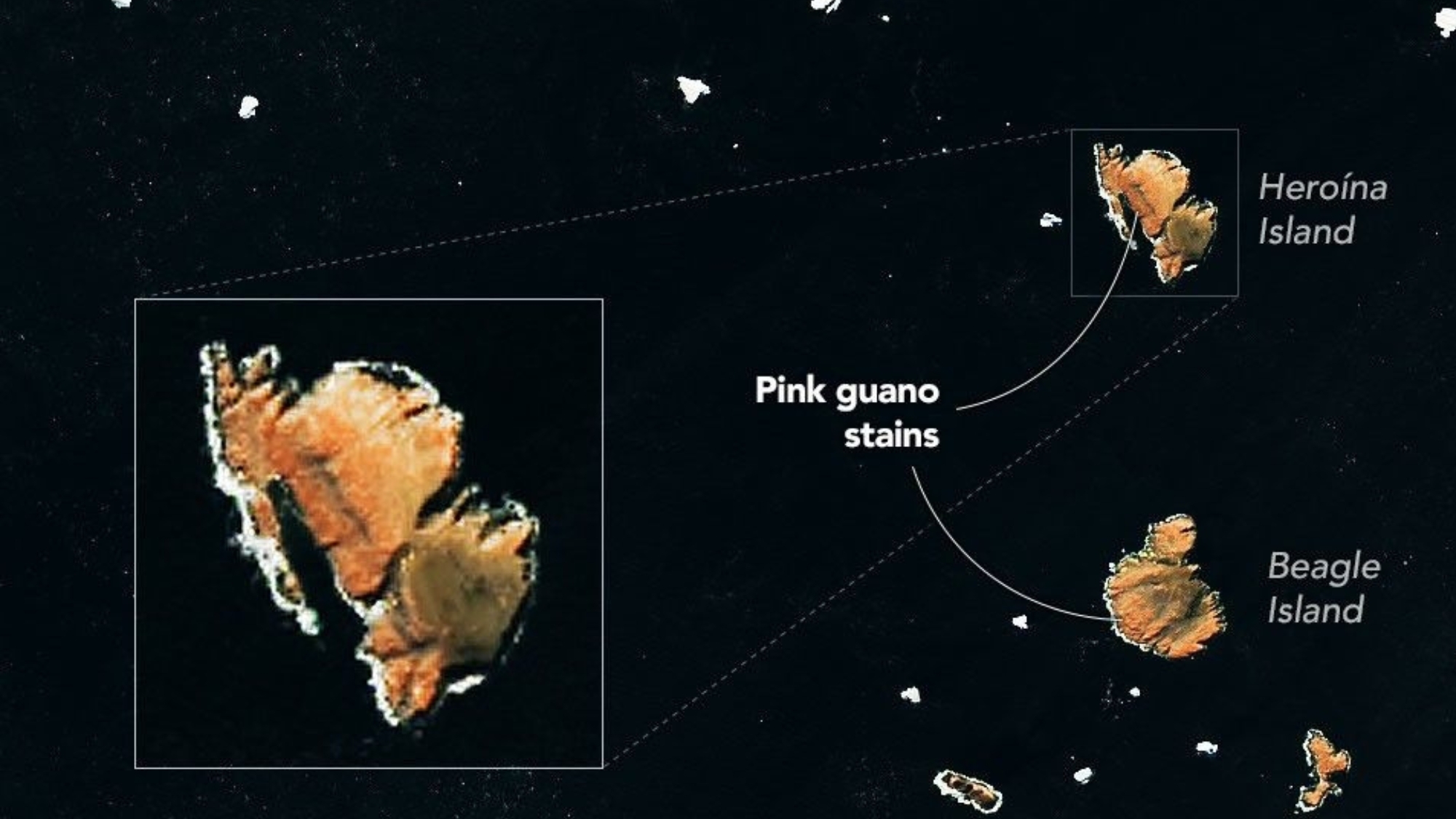
Pieces of sea ice drift near Antarctica's Danger Islands in this image, acquired on Jan. 22, 2023, by the Landsat 8 satellite. Several of the islands are stained pink by guano from Adélie penguins with a krill-rich diet. (Image credit: NASA Earth Observatory/Michala Garrison)
The diets of penguins on Antarctica's Danger Islands can be seen from space. At least indirectly.
Using satellite images captured by the Landsat 8 spacecraft operated by NASA and the United States Geological Survey, scientists can track changes in Adélie penguins' diets based on the color of their guano, or droppings.
What is it?
The image above shows pinkish-orange guano staining large sections of some of the Danger Islands, Heroína Island and Beagle Island. The penguins that live there eat a diet rich in krill, small marine crustaceans that are bright pink in color due to a specific type of algae upon which they feed.
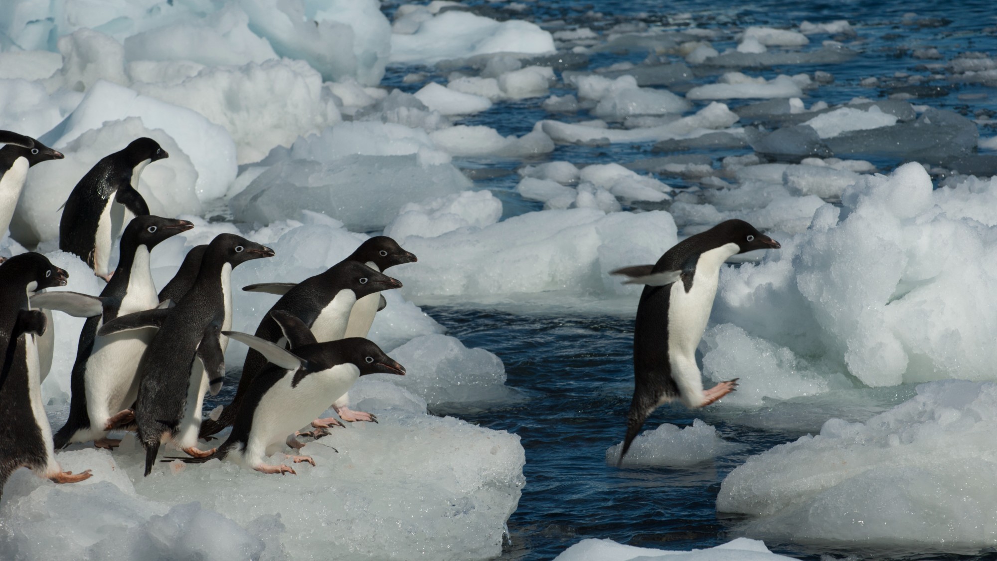
A group of Adelie penguins jumping from ice pebble to ice pebble on a beach of Paulet Island on the tip of the Antarctic Peninsula. (Image credit: Wolfgang Kaehler/LightRocket via Getty Images)
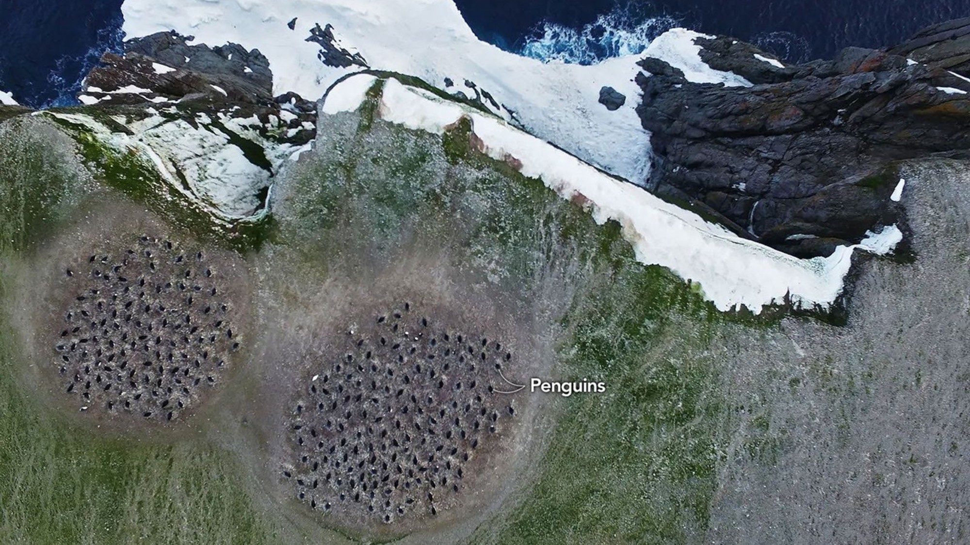
The bright pink color of the penguins' droppings stands out in satellite imagery, allowing researchers to monitor the birds' populations from space. But scientists wanted a closer look, and collected drone imagery as well, as seen in the image below.
A colony of Adélie penguins is visible in this image captured by a drone during a research expedition to the Danger Islands. (Image credit: Thomas Sayre-McCord/WHOI/MIT)
Why is it incredible?
It's pretty amazing that the diet of a specific population of birds can be monitored from 438 miles (705 kilometers) above Earth's surface. The imagery collected by Landsat-8 helped scientists locate where the penguin colonies might be, allowing them to find them in-person and collect guano samples. Those samples contained evidence of what the penguins were eating over time.
Researchers are using those satellite images and samples to track how the penguins' diet might be affected by changes in sea ice conditions, according to a NASA statement.
"Sea ice is such a hugely important factor in the Antarctic marine environment," said Clemson University biologist Casey Youngflesh who led a study comparing the penguins' diet and sea ice conditions. "The structure of the region's food web is changing in response."
Radio telescopes are designed to listen for signals from the stars and from distant galaxies, but scientists are also pointing out that these instruments can also track objects somewhat closer to home: junk in Earth's orbit.
Engineers have used thefamed radio telescope at Jodrell Bank in the U.K. as part of an international plan to watch high-altitude space debris. Normally, old satellites and bits of spacecraft stuck up ingeostationary orbit are too high up for our normal ways of watching space debris. However, said international project, called Long Baseline Multistatic Radar (LBMR), successfully used a radio telescope to get around this problem.
"That's the first time that's ever been done," Simon Garrington, associate director of Jodrell Bank, said ina video about the project.
A pressing problem
It's hardly a secret that junkis rapidly piling up in Earth's orbit — dead satellites, rocket remnants, rubble fromsatellite collisions oranti-satellite missile tests, and more. And as we keep filling Earth's orbit with thousands more satellites each year, we're also increasing the risk that one is struck by a debris fragment. We need to track this debris.
Most satellites exist in low Earth orbit (LEO) below altitudes of 1,250 miles (2000 kilometers), and indeed space debris is more concentrated at LEO. Still, there’s good reason to be just as concerned about debris in the much higher geostationary orbit (GEO), which falls 22,500 miles (36,000 kilometers) in altitude. Crucial communications and weather satellites lie in GEO, for instance, and space debris doesn't need to come in great quantities to pose a threat — just one unfortunate strike can cripple a satellite.
This leaves debris-hawks with a conundrum. They typically track space junk in LEO with radar, but most ground-based radar systems aren't sensitive enough to watch GEO's heights. Instead, they rely on optical telescopes to see objects in GEO. These telescopes are good for tracking larger objects (larger than about 4 inches, or 10 centimeters, across), but they can't resolve smaller objects as well as radar can. Yet these smaller objects can be just as deadly and destructive as their larger counterparts. If we want to see them with radar, we'll need especially sensitive receivers.
Fortunately, that equipment already exists, too — that's where radio telescopes can help.
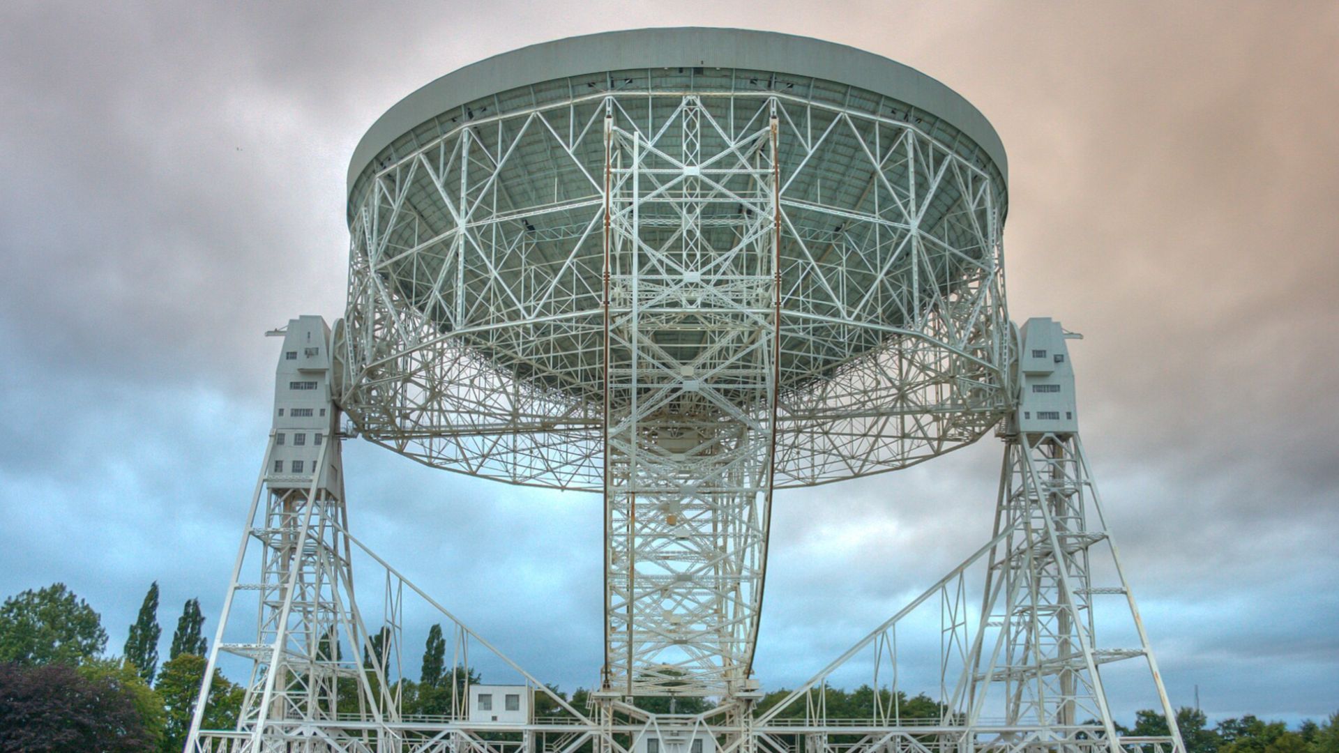
The Lovell Telescope (Image credit: By Mike Peel; Jodrell Bank Centre for Astrophysics, University of Manchester., CC BY-SA 4.0)
Engineers have tried debris-watching with radio telescopesas early as the 1990s, but LBMR, backed by NATO and the U.K. Space Agency, wanted to go further and watch debris in real time.
LBMR's engineers drew up a scheme to make this work. They would broadcast radio waves with a radar installation at the Massachusetts Institute of Technology'sLincoln Laboratory in the U.S. These radio waves would glance off debris and fall back into the dishes of U.K. radio telescopes such as theLovell Telescope at Jodrell Bank. Back on the ground, the radio telescope's signal would be processed and analyzed in real time.
Aligning a radar transmitter with a radio telescope on the far side of an ocean, then processing its signals, is far easier said than done.
"This idea started about seven years ago. It sounded at that time like a crazy idea, because we had no synchronization. We had assets on one end of the ocean and other assets on the other end of the ocean," saidMarco Martorella, an electronic engineer at the University of Birmingham and another member of LBMR, ina video. "But we were crazy enough to continue."
This required years of work, but the researchers have now successfully demonstrated that they can receive a signal with a single antenna. This has allowed them to track the distance to a piece of debris, and how quickly that distance is changing, in real time.
Next, the LBMR researchers hope to demonstrate that they can receive radar reflections of the same object with multiple radio telescopes at once. This, the researchers say, would allow debris-hawks to use the radio telescope technique to truly track debris in three dimensions.
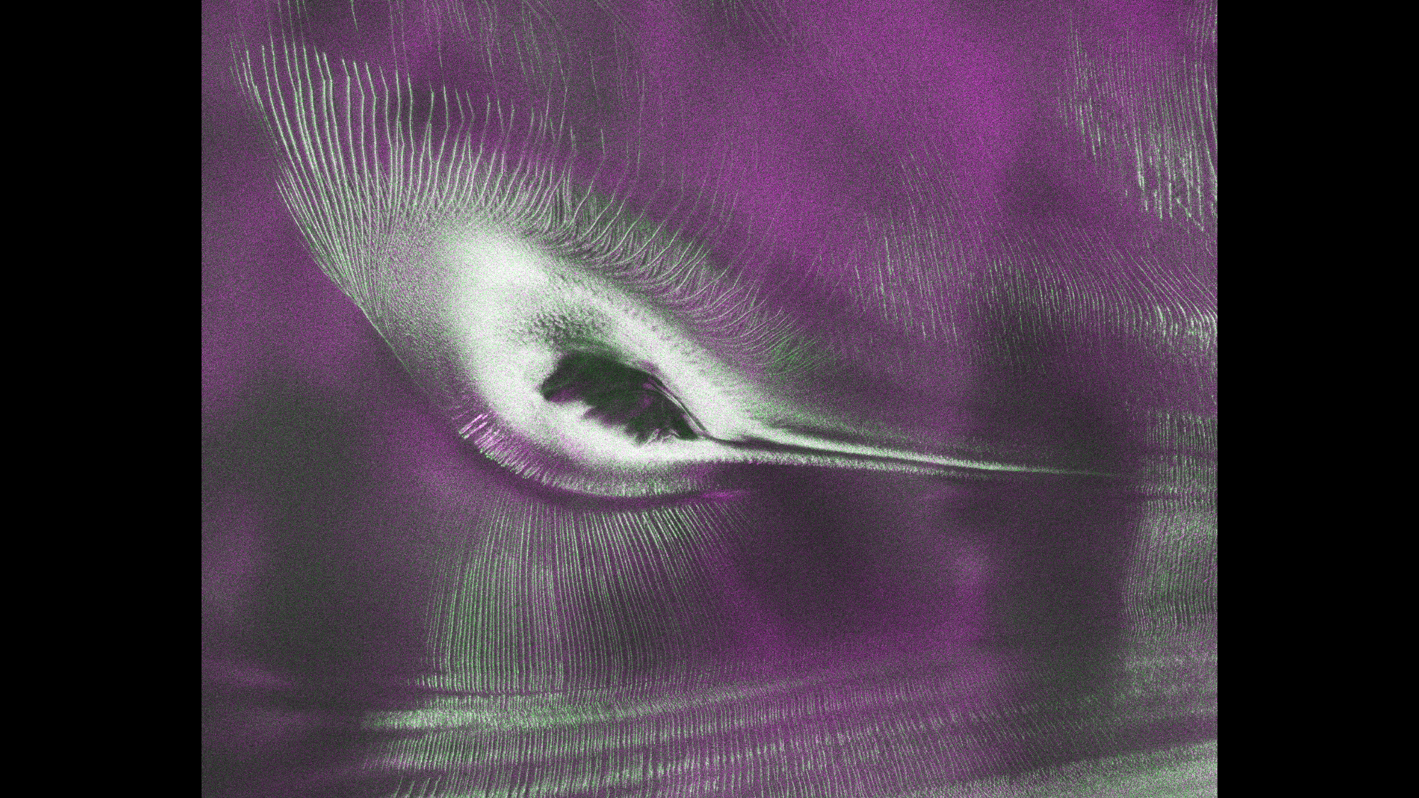
A hummingbird shape in satellite data from NISAR is actually a mountaintop spotted in Antarctica. (Image credit: NASA/JPL-Caltech)
In satellite data captured over Antarctica, what appears to be a beautiful, colorful hummingbird emerges from the crest of a mountaintop.
What is it?
While there are no hummingbirds flying around Antarctica, we can see what looks like a small, purple bird in a new satellite image of an Antarctic mountain. The dark belly of this "bird" at the center of this image is actually the top of the mountain Nunatak Zaterjavshijsja in East Antarctica.
What looks like a bird's tail is a stream of ice flowing northeast all the way out to the ocean, and what appear to be feathers splaying outward from the mountaintop are actually crevasses down the mountain. These crevasses are formed by a glacier fracturing the mountain's surface as it flows in the icy current toward the ocean.
This view was captured by radar instruments onboard the satellite NISAR (NASA-ISRO Synthetic Aperture Radar) that launched as a collaboration between NASA and ISRO (Indian Space Research Organisation). The director of NASA's Earth Science Division called NISAR "the most sophisticated radar we've ever built" in a pre-launch briefing last year.
Why is it incredible?
At first glance, this image is puzzling. What could it possibly be? Its bold colors and sharp lines evoke almost alien qualities. But the strange beauty of the shapes and colors in this satellite image reveal important information about glacier movements on the mountain.
"First, it's a beautiful image, with rich details of features that provide insights to how the glacier is moving. Then, because radar can often see through snow and deep into the ice, NISAR can observe fundamentally different properties of Antarctic ice than can be seen in optical imagery," Seongsu Jeong, the signal analysis engineer who produced the image at NASA's Jet Propulsion Laboratory, said in a statement. "With NISAR we're seeing what's hidden beneath the surface."
And now anyone can explore NISAR's data. Earlier this week, on July 20, NISAR started making the data from its radar instruments public. Moving forward, mission teams will be rolling out this data so researchers everywhere can use it to study and protect our ever-changing planet.
An amateur astronomer's plans for a camping vacation two years ago transformed into a possible crater find in Canada's north.
Amateur astronomer Joël Lapointe, using Google Maps to figure out his route for the 2024 vacation, saw some odd terrain in Quebec's Côte-Nord region centered on Lake Marsal. Lapointe suspected it was an impact crater from a meteorite, and made a report on Impact Earth — a crowdsourcing website for craters with Canada's Western University in London, Ontario near Toronto. Western planetary geologist Gordon Osinski made a visit to the region in 2025, provisionally not only confirming the crater, but saying it's probably one of the biggest discovered in recent years. The 390-million-year old feature is roughly 15 miles (25 kilometers) wide.
In an email interview with Space.com while on travel in Scotland, Osinski — known as "Oz" by the space community — said to his knowledge the last discovery of that scale was the approximately 31-km (19-mile) Hiawatha structure, also possibly a crater, spotted in Greenland in 2018. "However, that structure is completely buried by ice, so its diameter is uncertain and there is still some controversy about its origin," Oz said.
But in the case of the new crater, called Uhackatik with approval from the Innu Council of Ekuanitshit in whose traditional lands the crater lies, there is no doubt at all where the crater came from. Oz's expedition to the area revealed "shock metamorphic effects", which are deformations to the rocks induced by the shock waves and heating produced by a meteorite impact.
"Impact melt rocks are like they sound: large volumes of rock that are melted by the impact event, but then cool and crystallize to look a lot like volcanic rocks," he said. "Finding these preserved — as they are usually some of the first parts of a crater to be eroded — was a big surprise."
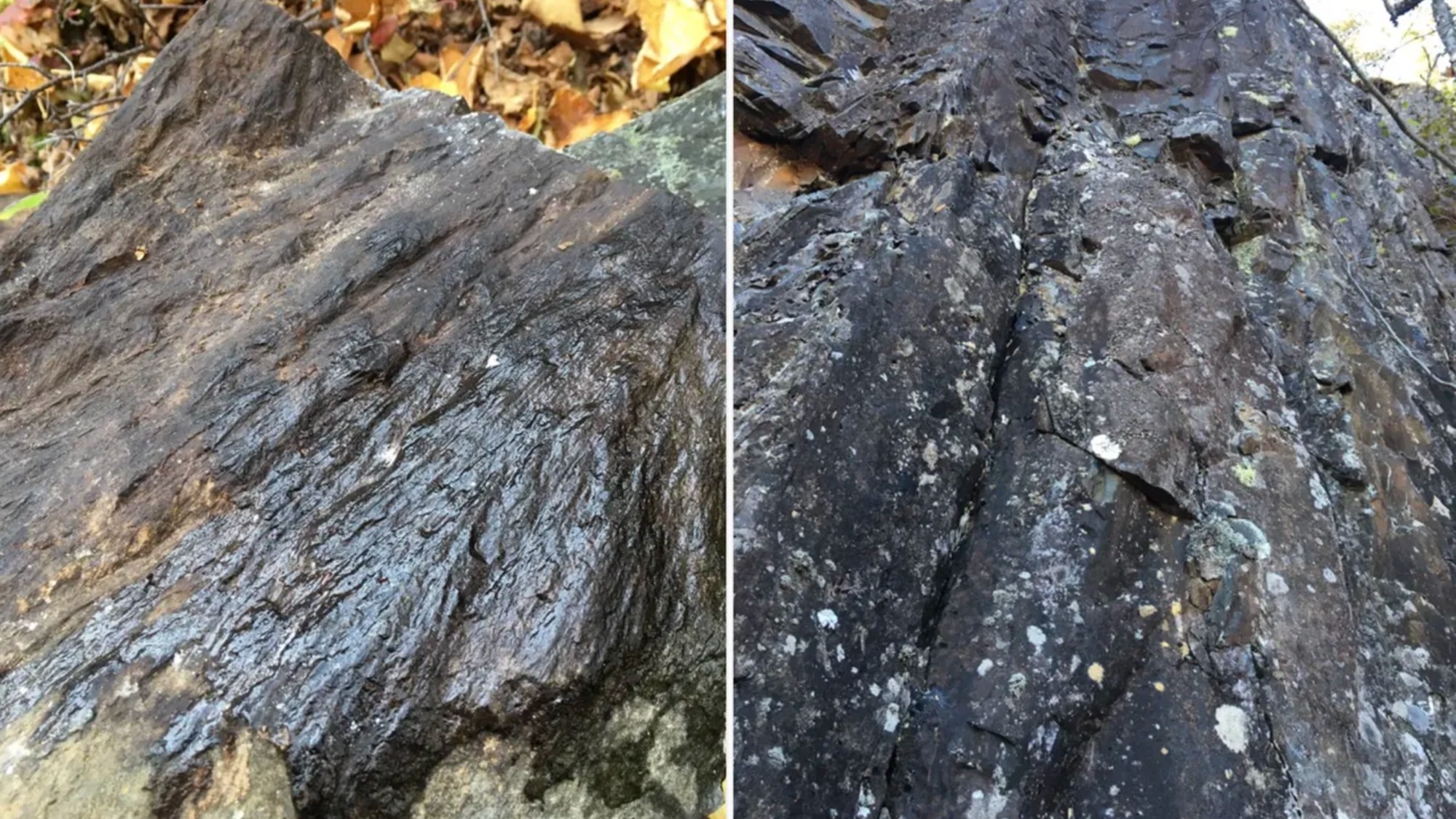
While most of the features are microscopic, Oz said in the field he and his collaborators could easily see "shatter cones", which are branching features in rock layers produced by the shockwave of impact. The research is not yet peer-reviewed, but it will be presented at the 88th Annual Meeting of the Meteoritical Society in Frankfurt, Germany in August.
A shatter cone seen in rocks found at the center of the structure (left); melt rock found 2.5 miles (4 kilometers) west of the structure's center. (Image credit: Gattacceca, J. et al.)
While 400-million-year-old impact craters on Earth are hard to find, as geologic activity as well as erosion change their features over time, the precious evidence is helpful for scientists to better understand meteorite impacts on the moon, Mars and other rocky extraterrestrial bodies.
In terms of age, Oz noted, the moon's prominent Tycho crater best represents what Uhackatik probably looked like 390 million years ago. But On Earth, one of the best comparisons to Uhackatik is a moon-like crater used to help the Artemis II astronauts get ready for their moon mission this year.
That Earth crater is called Kamestastin (also known as Mistastin) in northern Labrador, Canada. Oz regularly runs expeditions there in consultation with the Mushuau Innu First Nation, as the crater lies within their traditional hunting grounds. Kamestastin includes anorthosite, a common mineral found in craters at the moon's south pole, where NASA hopes to land astronauts under the US-led Artemis program.
"For comparative craters [to Uhackatik], Kamestastin is actually a great one as the size is very similar," Oz said. "Kamestastin is well-preserved and I've worked there a lot … so in my mind, I was using Kamestastin as a template for exploring this new potential crater."
To fully confirm Uhackatik's extraterrestrial origin, Oz and collaborators are examining samples microscopically for more evidence of shock effects, such as chemistry indicating a high-temperature melt, or deformation effects in the quartz. In the meantime, Oz's lunar work with NASA continues: he will be part of the geology teams supporting the moon-landing astronauts during the Artemis 4 and 5 missions, which will touch down as soon as 2028.
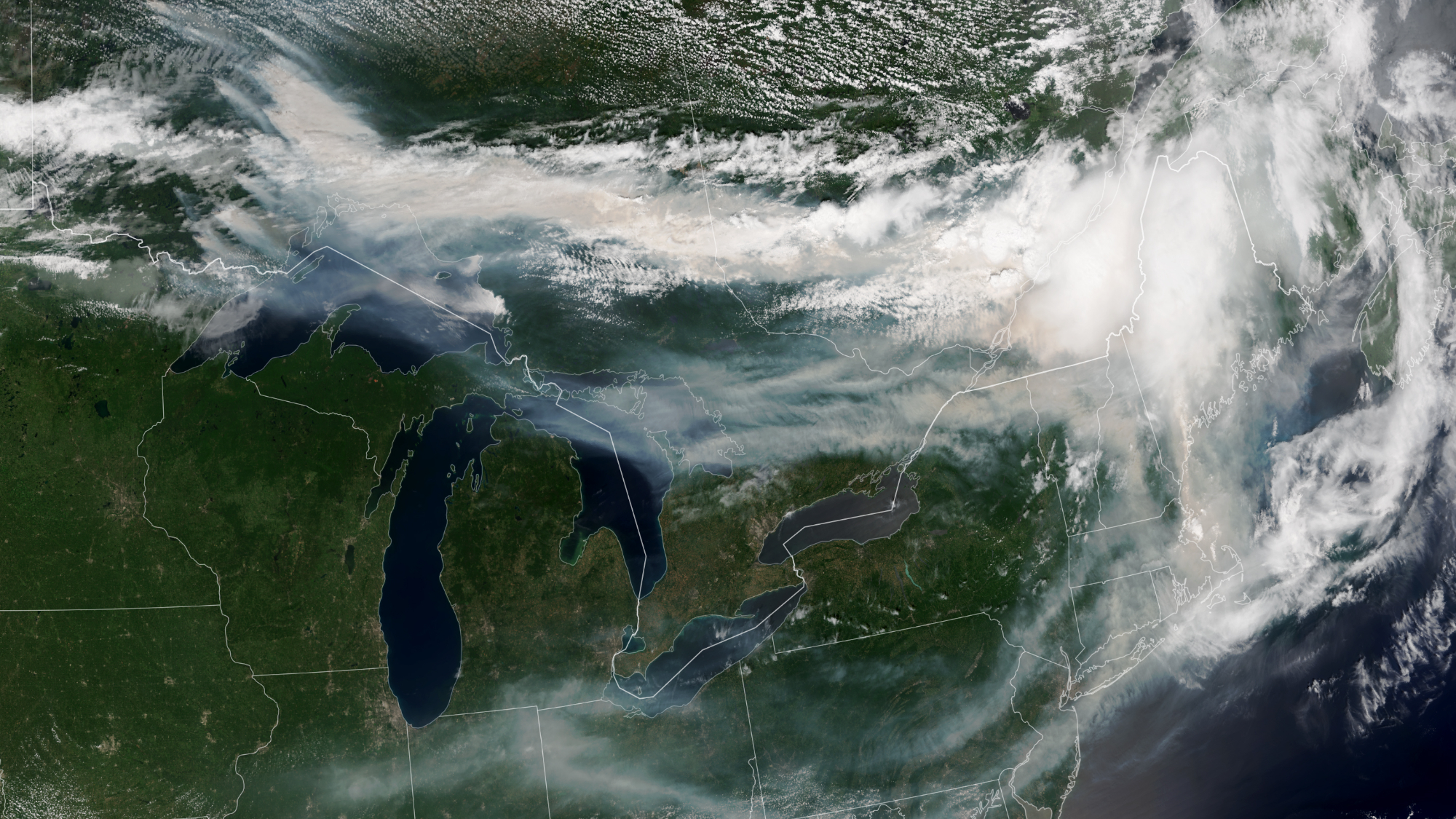
Smoke from wildfires across Canada travels across both Canada and the U.S. in this satellite image captured by NOAA-21 on July 14, 2026. (Image credit: NASA Earth Observatory/Lauren Dauphin)
The wildfires tearing across Canada are so extreme that the smoke billowing upward can be seen from space.
What is it?
Over 850 wildfires are currently devastating Canada, as reported by theCanadian Interagency Forest Fire Center. The fires are spreading across Manitoba, Saskatchewan and Ontario; most remain completely uncontrolled.
In addition to the immense destruction caused by the fires themselves, the smoke from these fires is causing serious concerns about dangerously poor air quality all across Canada and even in the northeastern United States. As far as New York, the air quality on Thursday (July 16) was labeled "very unhealthy" after the state activated emergency air quality protocols.
The smoke is so expansive it's clearly visible in this image captured on July 14 from Earth orbit.
Why is it noteworthy?
Studying wildfires and wildfire smoke from orbit can give us a bigger picture view of these catastrophic event. This data is important for disaster relief in the short term — but also in the long-term. With climate change continuing to progress due to human activities like burning coal for cheap power, we can expect natural disasters to worsen. Among the many effects of climate change, this includes longer and more intense wildfire seasons, especially in regions that are already susceptible to fire such as these regions across Canada.
The new image was captured by the NOAA-21 satellite with the instrument VIIRS (Visible Infrared Imagine Radiometer Suite). You can see massive plumes of smoke over southeastern Canada treading into the northeastern U.S. Thick smoke covers swaths of Canada's landscape and wisps of smoke trail all the way down through New York and across the U.S.
Most of this smoke, at least the smoke we can see in this satellite image, is coming from wildfires in northwestern Ontario. As the wildfires continue to burn, satellites like NOAA-21 will be keeping watch.
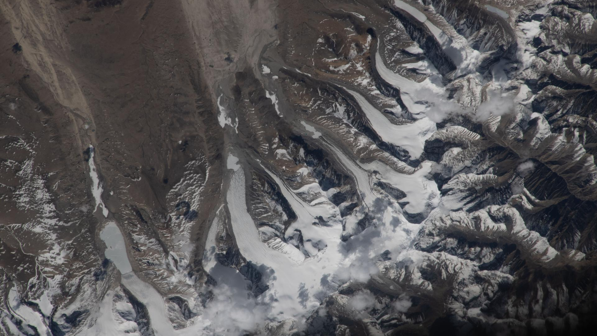
Glaciers flow across the Himalaya, as seen from the International Space Station. (Image credit: NASA/Jessica Meir)
Towering glaciers flow down the Himalayas' northern slopes like icy giants cascading onto China's Tibetan Plateau.
What is it?
Back in May, from aboard the International Space Station 259 miles (417 kilometers) above Earth, NASA astronaut Jessica Meir peered out the station's windows with her camera and captured a breathtaking sight.
In that fleeting moment from space, she captured the northern slopes of the Himalaya mountains stretching into China. And atop the mountains, slow-moving rivers of glacial ice carve their way downhill.
This view shows the enormity of this mountain range, which separates Nepal from China's Tibetan Plateau. The Himalayas have the highest mountains in the world, including Mount Everest, with over 110 mountain peaks surpassing 24,000 feet (7,300 meters) of elevation above sea level. Ranging across five countries (Nepal, India, China, Bhutan and Pakistan) the mountain range is about 1,500 miles (2,400 kilometers) wide.
Why is it incredible?
With the range being so incredibly expansive, this view from space offers a unique vantage point from which we can see a large swath of the mountains in motion. Even in a helicopter, you would get a fairly localized view of individual mountains in the Himalayas. This view provides a striking scene that you cannot see from the surface of our planet.
This view is also a reminder of how important space is in our evolving understanding of climate change. As our planet continues to change and sea levels rise with warming temperatures, we can see glacial movement from space. This is an important resource to researchers fighting to better understand climate change so we can better fight it. With access to information about glaciers and how they melt, move and flow across the world, we can be better prepared to protect our planet and its inhabitants.
Cutting back on our use of energy and materials so that we live within Earth’s means can seem like an insurmountable challenge. But after a decade grappling with these problems, a historic Portuguese city is beginning to walk this tightrope
Environmental and scientific organizations are banding together to demand federal environmental reviews of space-based data center projects, which plan to put more than a million new satellites in Earth orbit over the coming years.
Over the last few months, a number of different companies have requested licenses from the U.S. Federal Communications Commission (FCC) to launch data centers into space. SpaceX's proposal alone requests licenses for up to one million satellites in low Earth orbit (LEO). But the requested licenses don't come with any environmental review of the impacts that the satellites — especially collectively — could have on dark skies, wildlife or our atmosphere. In response, a coalition of environmental and scientific organizations represented by the environmental nonprofit Earthjustice have petitioned the FCC for this review.
"Allowing a million orbiting data centers with no environmental review isn’t just irresponsible — it’s reckless," Tim Whitehouse, executive director of Public Employees for Environmental Responsibility, said in a statement on Wednesday (July 8). "The potential for these projects to degrade the atmosphere with pollution and debris and harm wildlife needs to be carefully considered before licensing these projects."
Space is big, but a million new satellites added to LEO to support space-based data centers would be a massive increase. Currently, just Earth orbit harbors just 15,000 active satellites and 46,000 tracked objects overall. This number was already on track to grow to 58,000 active satellites, thanks in large part to SpaceX's ever-growing Starlink broadband megoconstellation, but the data-center plans could make it absolutely explode.
Experts suggest that this significant addition to the technological ecosystem in orbit could have disastrous consequences for life on Earth.
"Drastically expanding satellites in space has a direct impact on people’s everyday lives as well as the future of our planet," Jan Hasselman, senior attorney at Earthjustice, said in the statement. "Agencies that authorize companies looking to space as the next frontier still must operate within the law, and the law requires the FCC to consider all the risks and impacts of these proposals. If we have to sue so that they comply, we will."
The FCC has not yet required any environmental review for satellite companies seeking authorization to deploy in LEO. With its new petition, this coalition aims to change that, asking the FCC to stop granting licenses for orbiting data centers without an environmental review.
What possible environmental harms are they worried about? First of all, as more and more satellites are added to the orbital population, the greater chance there is of collisions, which could produce debris that not only clutters Earth orbit but also increases the risk of additional collisions.
Further the rocket launches that propel the satellites to orbit contribute greenhouse gas emissions to our atmosphere. And the spacecraft cause further pollution when they deorbit, releasing heavy metals and other materials when they burn up in Earth's air.
In addition, a massive increase in satellites will fundamentally change the night sky. Light pollution is known to impact wildlife and ecosystems, disrupting natural rhythms and influencing everything from migration patterns to daily feeding schedules. These disruptions can push animals like bats to miss windows in which insect prey are available, causing them to starve. They can also prevent mountain lions — apex predators that uphold their local ecosystems — from roaming normally at night, fragmenting populations over time, according to the National Wildlife Federation.
The effects of light pollution on wildlife would doubtless grow if suddenly a million new, blinking satellites were added to our night skies. And issues with light pollution extend to our species as well, as life would look quite different if our night skies were much more crowded by bright lights.
"These projects could permanently alter the night sky as we know it," Ruskin Hartley, executive director of DarkSky International, said in the statement. "The FCC needs to take seriously its obligation to ensure these projects do not cause unnecessary harm to naturally dark skies, or to our overall environment."
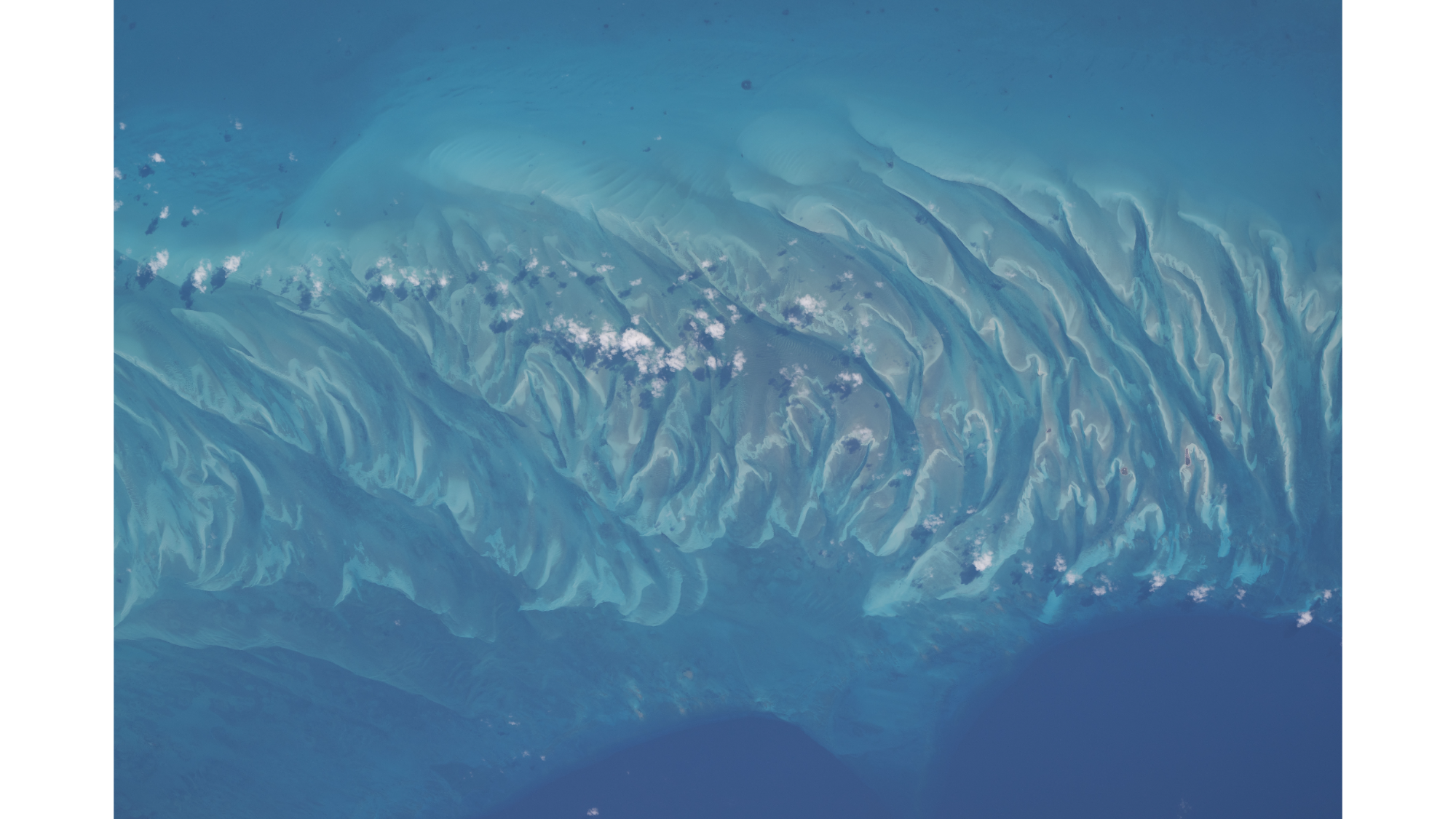
Sandbars and waves of rippling sand dunes can be seen from space amongst the turquoise ocean in the Bahamas. (Image credit: NASA/Chris Williams)
If you look at this picture for too long, you might start to hear the waves lapping up against the shore or feel a salty breeze in the air.
You might not have a trip to the Bahamas planned, but you can always enjoy its beauty in this spectacular summertime snapshot captured by NASA astronaut Chris Williams from aboard the International Space Station.
What is it?
In a snapshot that looks straight out of a travel commercial, we can see the crests of rippling waves of sand peeking out from beneath turquoise waters off the coast of the island Eleuthera in the Bahamas.
The moment was captured 263 miles (423 kilometers) above Earth's Atlantic Ocean from aboard the space station orbiting our planet.
This isn't the first fun snapshot captured by Williams who also recently flexed his muscles for a photo mid-spacewalk.
Why is it incredible?
This photo is incredibly beautiful. That much is immediately obvious. And if you've ever swam in picturesque waters like this, then you know how calming and magical such places on Earth can be.
But this photo is more than just pretty, as it shows that we can see Earth's beauty from 263 miles away. It is a reminder that our planet is truly special. Imagine if a future mission saw beauty like this from space on a far off exoplanet, or even a planet outside of our solar system. Currently, our planet is the only one we know of with views like this, but it's possible that in the future we might find tropical shorelines and vacation vistas aren't exclusive to our home planet.