Cutting back on our use of energy and materials so that we live within Earth’s means can seem like an insurmountable challenge. But after a decade grappling with these problems, a historic Portuguese city is beginning to walk this tightrope
Environmental and scientific organizations are banding together to demand federal environmental reviews of space-based data center projects, which plan to put more than a million new satellites in Earth orbit over the coming years.
Over the last few months, a number of different companies have requested licenses from the U.S. Federal Communications Commission (FCC) to launch data centers into space. SpaceX's proposal alone requests licenses for up to one million satellites in low Earth orbit (LEO). But the requested licenses don't come with any environmental review of the impacts that the satellites — especially collectively — could have on dark skies, wildlife or our atmosphere. In response, a coalition of environmental and scientific organizations represented by the environmental nonprofit Earthjustice have petitioned the FCC for this review.
"Allowing a million orbiting data centers with no environmental review isn’t just irresponsible — it’s reckless," Tim Whitehouse, executive director of Public Employees for Environmental Responsibility, said in a statement on Wednesday (July 8). "The potential for these projects to degrade the atmosphere with pollution and debris and harm wildlife needs to be carefully considered before licensing these projects."
Space is big, but a million new satellites added to LEO to support space-based data centers would be a massive increase. Currently, just Earth orbit harbors just 15,000 active satellites and 46,000 tracked objects overall. This number was already on track to grow to 58,000 active satellites, thanks in large part to SpaceX's ever-growing Starlink broadband megoconstellation, but the data-center plans could make it absolutely explode.
Experts suggest that this significant addition to the technological ecosystem in orbit could have disastrous consequences for life on Earth.
"Drastically expanding satellites in space has a direct impact on people’s everyday lives as well as the future of our planet," Jan Hasselman, senior attorney at Earthjustice, said in the statement. "Agencies that authorize companies looking to space as the next frontier still must operate within the law, and the law requires the FCC to consider all the risks and impacts of these proposals. If we have to sue so that they comply, we will."
The FCC has not yet required any environmental review for satellite companies seeking authorization to deploy in LEO. With its new petition, this coalition aims to change that, asking the FCC to stop granting licenses for orbiting data centers without an environmental review.
What possible environmental harms are they worried about? First of all, as more and more satellites are added to the orbital population, the greater chance there is of collisions, which could produce debris that not only clutters Earth orbit but also increases the risk of additional collisions.
Further the rocket launches that propel the satellites to orbit contribute greenhouse gas emissions to our atmosphere. And the spacecraft cause further pollution when they deorbit, releasing heavy metals and other materials when they burn up in Earth's air.
In addition, a massive increase in satellites will fundamentally change the night sky. Light pollution is known to impact wildlife and ecosystems, disrupting natural rhythms and influencing everything from migration patterns to daily feeding schedules. These disruptions can push animals like bats to miss windows in which insect prey are available, causing them to starve. They can also prevent mountain lions — apex predators that uphold their local ecosystems — from roaming normally at night, fragmenting populations over time, according to the National Wildlife Federation.
The effects of light pollution on wildlife would doubtless grow if suddenly a million new, blinking satellites were added to our night skies. And issues with light pollution extend to our species as well, as life would look quite different if our night skies were much more crowded by bright lights.
"These projects could permanently alter the night sky as we know it," Ruskin Hartley, executive director of DarkSky International, said in the statement. "The FCC needs to take seriously its obligation to ensure these projects do not cause unnecessary harm to naturally dark skies, or to our overall environment."
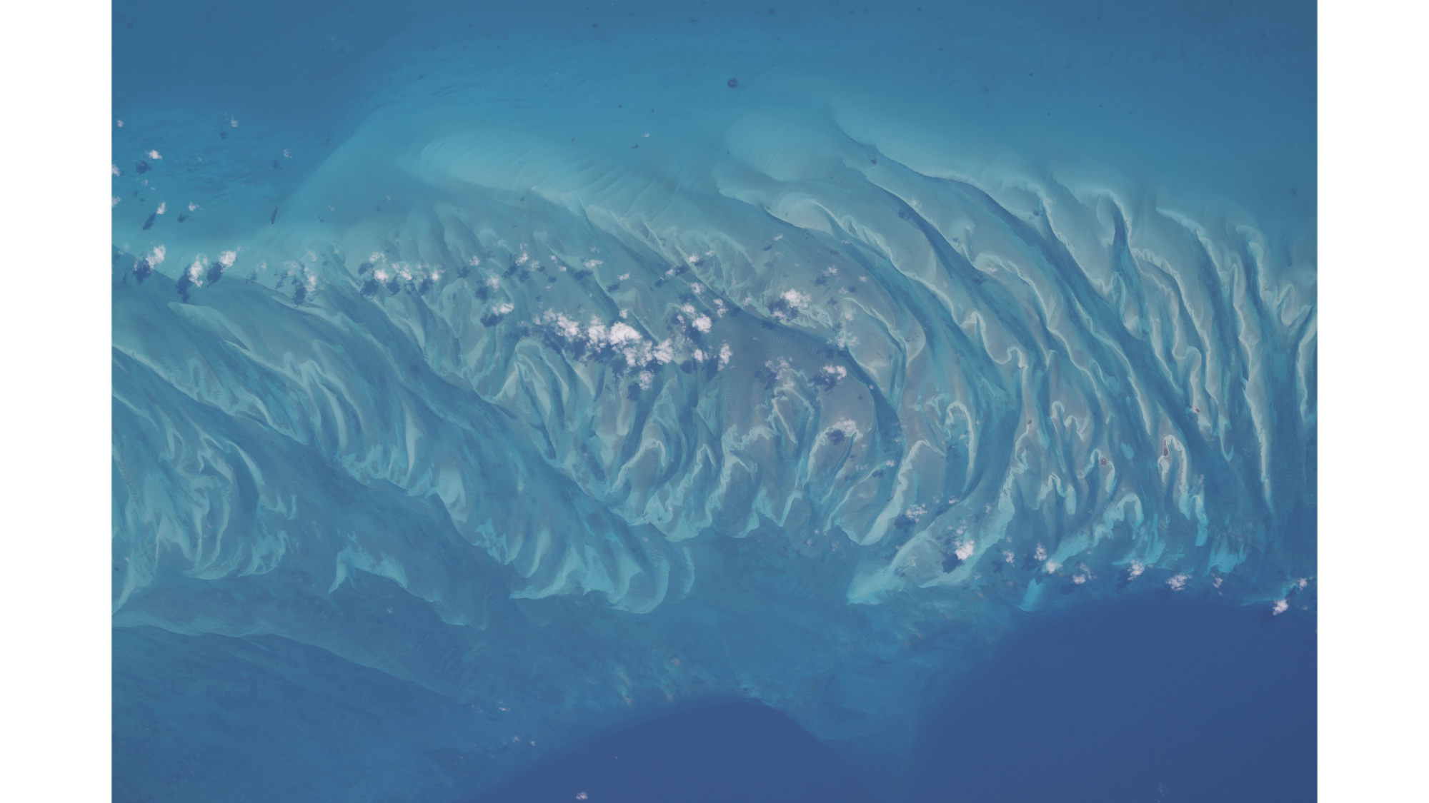
Sandbars and waves of rippling sand dunes can be seen from space amongst the turquoise ocean in the Bahamas. (Image credit: NASA/Chris Williams)
If you look at this picture for too long, you might start to hear the waves lapping up against the shore or feel a salty breeze in the air.
You might not have a trip to the Bahamas planned, but you can always enjoy its beauty in this spectacular summertime snapshot captured by NASA astronaut Chris Williams from aboard the International Space Station.
What is it?
In a snapshot that looks straight out of a travel commercial, we can see the crests of rippling waves of sand peeking out from beneath turquoise waters off the coast of the island Eleuthera in the Bahamas.
The moment was captured 263 miles (423 kilometers) above Earth's Atlantic Ocean from aboard the space station orbiting our planet.
This isn't the first fun snapshot captured by Williams who also recently flexed his muscles for a photo mid-spacewalk.
Why is it incredible?
This photo is incredibly beautiful. That much is immediately obvious. And if you've ever swam in picturesque waters like this, then you know how calming and magical such places on Earth can be.
But this photo is more than just pretty, as it shows that we can see Earth's beauty from 263 miles away. It is a reminder that our planet is truly special. Imagine if a future mission saw beauty like this from space on a far off exoplanet, or even a planet outside of our solar system. Currently, our planet is the only one we know of with views like this, but it's possible that in the future we might find tropical shorelines and vacation vistas aren't exclusive to our home planet.
For decades, astronomers have debated whether Earth's fate was tied to the sun's. When the star exhausts the hydrogen fuel that powers it about 5 billion years, it will swell into a red giant large enough to engulf Mercury and Venus — and, several studies have suggested, Earth as well.
New research, however, suggests our planet has a better chance of escaping that fiery end than previously thought. Using updated models of how aging stars interact with their planets, researchers found that the gravitational forces drawing Earth toward the expanding sun are weaker than older models predicted. That would give the planet more time to drift outward as the dying sun sheds its outer layers into space, potentially avoiding engulfment altogether.
The finding does not guarantee Earth's survival. Instead, researchers say it shifts the biggest uncertainty from how strongly the expanding sun tugs on planets to the poorly understood variable of how much mass the star will lose during its final stages of evolution.
"The largest uncertainty no longer comes from the tidal calculations, but from how much mass the future sun will lose," study lead author Mats Esseldeurs of the KU Leuven's Institute of Astronomy in Belgium said in a statement. "Observations of sun-like giant stars currently point towards Earth's survival, but we need better observations before we can be certain."
When stars like the sun exhaust their core hydrogen and balloon into massive red giants, they trigger a cosmic tug-of-war between expanding tidal forces pulling planets inward and shedding stellar weight pushing them outward, which ultimately decides whether nearby worlds are engulfed or saved.
This planetary push-and-pull unfolds in two stages. As the sun expands, gravitational tides act like a subtle brake, slowly draining Earth's orbital energy and pulling the planet inward. At the same time, the dying star sheds vast amounts of gas through powerful stellar winds, eventually losing about half its mass. As the sun grows lighter, its gravitational grip weakens, pushing the surviving planets outward into a wider orbit that could double their distance from the star, according to NASA.
"The fate of Earth depends on a delicate balance between these two effects," Esseldeurs said in the statement. "If tidal interactions dominate, Earth is engulfed. If mass loss dominates, Earth escapes to a wider orbit."
Previous studies reached different conclusions mostly because they treated those competing processes differently, Esseldeurs and his team argue. A few of those studies neglected tidal interactions altogether, while others relied on simplified prescriptions developed decades ago that predicted a much stronger inward pull, according to the study.
Instead of relying on those older formulas, the new study uses updated calculations of tidal forces based on the shifting internal structure and dynamics of aging stars — which the team says allowed it to precisely account for both tidal friction and shifting stellar winds — before testing the results against a range of possible mass-loss rates for the sun's final giant phase.
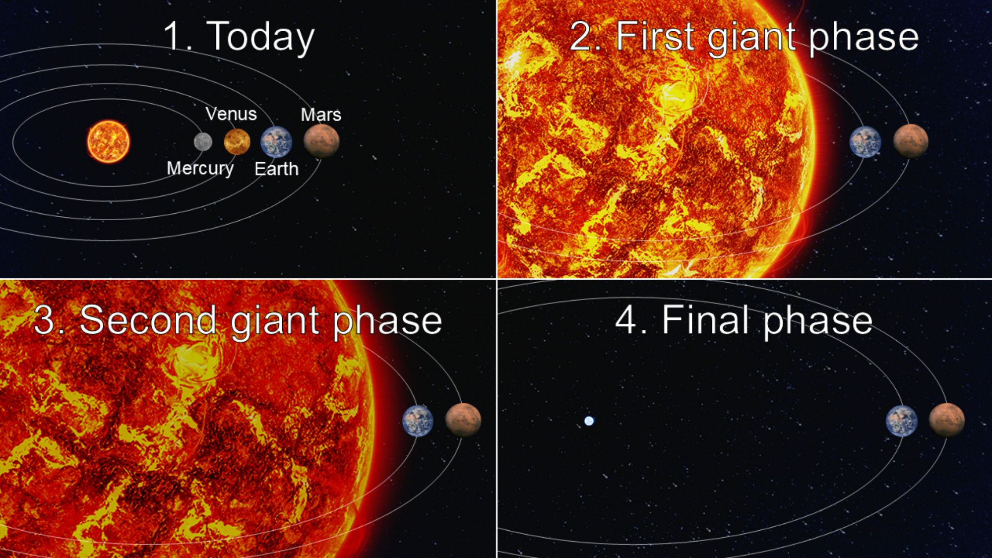
The results suggest that even with the weaker inward gravitational pull, Mercury and Venus are unable to outpace the expanding sun and are inevitably engulfed, while Earth and Mars migrate safely through both giant phases, leaving our planet to eventually settle into a broader orbit around the white dwarf remnant the sun will leave behind, the study found.
A schematic evolution of the sun as it goes through its giant phases. The image showed the sun as it is today, going through its two giant phases, before ending its life as a white dwarf. The study showed that Mercury and Venus will be engulfed by the expanding sun, but Earth and Mars survive, ending up in a wider orbit. Sizes and distances are not to scale. (Image credit: Institute of Astronomy of KU Leuven)
The picture is far from settled, however. Because astronomers still cannot precisely observe how rapidly sun-like stars lose mass late in life, "the ultimate fate of the Earth remains uncertain," the researchers write in the new paper.
By factoring in real-world mass-loss rates from L2 Pup — a red giant star roughly 183 light-years away that was used as a proxy for our future sun due to its similar mass — the researchers confirmed that Earth will drift outward just quickly enough to avoid being swallowed, tipping the scales toward survival over destruction, the study notes.
For us humans, the finding offers academic comfort rather than practical salvation. Most scientists agree that as the sun ages, it will steadily grow hotter, boiling Earth's oceans and rendering the planet completely uninhabitable in about 1 billion years, long before the sun begins to expand.
Yet even if humans aren't around to witness it, tracking Earth's ultimate survival provides important context for how planetary systems evolve as their stars age, a framework that researchers say will be further refined by future observations of dying, sun-like stars.
"This will enable us to conduct population studies of the planetary orbital evolution around evolved stars," the researchers wrote in the paper, "and help us to constrain the future evolution of the Earth-sun system."
The study was published in June in the journal Astronomy & Astrophysics.
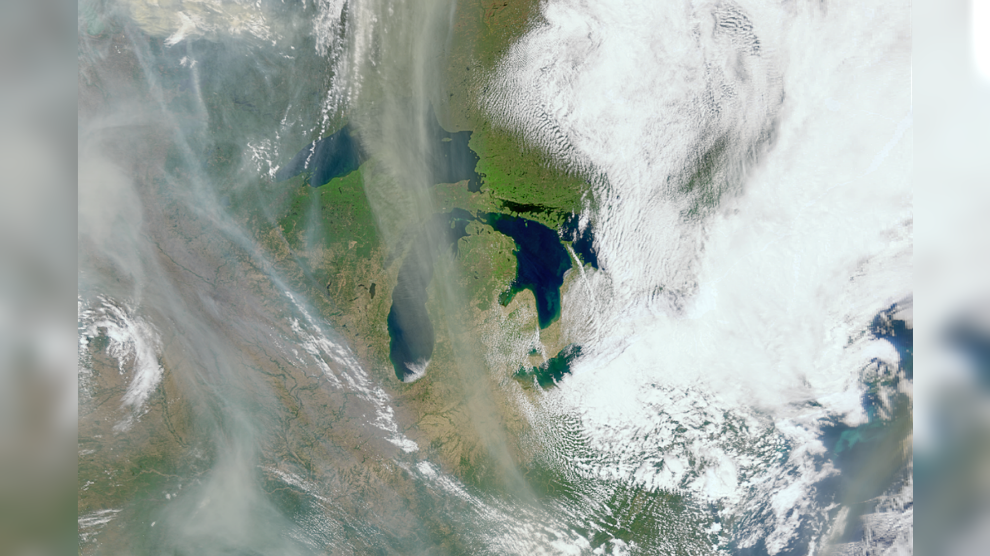
Swirls of wildfire smoke can be seen over Canada. (Image credit: NASA)
Wildfires across the globe can be seen all the way from space. And one unexpected tool has come in handy to spot plumes of wildfire smoke: a satellite designed to study Earth's oceans.
What is it?
In this photo, we can see swirls of wildfire smoke over the Great Lakes in Canada. Fluffy white clouds float over the land and lakes, in contrast to the wisps of gray smoke, which float out from massive wildfires that ripped through North America.
The photo was snapped in May of last year by NASA's PACE (Plankton, Aerosol, Cloud, and ocean Ecosystem) satellite. This seems logical, as it is an Earth-monitoring satellite, but what's surprising is that the orbiting spacecraft was actually designed to study and monitor Earth's oceans and atmosphere. In fact, the image itself was captured by PACE's Ocean Color Instrument, which does "hyperspectral" imaging, meaning that it observes the planet in hundreds of different wavelengths of light (in visible, near-infrared and ultraviolet).
Why is it incredible?
This image, among others, shows the incredible versatility of space technologies like PACE. While wildfire monitoring isn't its explicit purpose, images and data from this mission could be incredibly helpful in deepening our understanding of wildfires and how they spread.
"The PACE satellite observes land too, and does it really well," Skye Caplan, terrestrial lead for the PACE mission at NASA's Goddard Space Flight Center in Maryland, said in a statement. "There is so much to explore with a new hyperspectral data set."
In fact, in addition to capturing wildfire smoke, as we can see in this image, PACE's Ocean Color Instrument can also spot changes in vegetation, burn scars and the charred aftermath of a wildfire. Images in the instrument's hundreds of wavelengths can reveal a variety of detailed information, such as how stressed, dry or even pigmented plants are on Earth's surface. This type of information could also be beneficial in identifying dry areas that could be at a higher risk of wildfires sparking.
Every year, millions of people travel to remote, protected "dark-sky parks" in search of experiences that depend on true darkness — photographing the Milky Way's heart arcing overhead, observing nocturnal wildlife in its natural rhythm, or simply standing beneath an ink-black sea of stars unblurred by artificial light.
Scientists have long warned that rising levels of artificial light — increasingly amplified by satellite megaconstellations orbiting our planet — are steadily eroding these nightscapes, disrupting ecosystems, affecting human health and dimming views of stars and distant celestial objects. Darkness itself carries no price tag, however, meaning its loss has largely been absent from the economic calculations that guide development and outdoor lighting decisions. Now, new research attempts to translate that loss visible in monetary terms.
A study combining satellite data with on-the-ground surveys of visitors at several "gold-tier" dark-sky sites found that people were less likely to choose parks with greater artificial skyglow or poorer night-sky conditions, and showed a clear willingness to pay more for darker skies.
On average, visitors would pay about $18 more per trip for marginally darker skies, and roughly $45 more per night for a one-step improvement on the Bortle Dark Sky Scale, a widely used measure of night-sky quality.
"This may seem really small at the per-visitor and per-trip unit estimate," said Jordan Smith, the study's lead author and director of the Institute of Outdoor Recreation and Tourism at Utah State University, "but when we scale through park-wide visitation, it becomes very, very significant."
Over a four-month period, the researchers estimated that light pollution reduced the recreational value of flagship dark-sky destinations in the U.S. by between $25 million and nearly $66 million.
The figures, presented at the 248th meeting of the American Astronomical Society in California, do not represent lost park revenue, but what economists call "welfare losses" — the decline in visitor satisfaction when environmental quality deteriorates. The concept is akin to paying for a concert expecting excellent sound and instead finding the speakers distorted; the performance still occurs, but it feels worth less than anticipated.
By assigning a dollar value to changes in night-sky quality, the researchers argue, policymakers gain a way to weigh the hidden costs of artificial lighting against the benefits of development and outdoor illumination.
"It's a foundational building block that allows that cost-benefit analysis to subsequently occur," Smith said.
Speaking at a press briefing during the conference, Smith said a central challenge is the gap between measuring light pollution and measuring what it costs in lived experience. Satellites and ground instruments can track where artificial light is spreading and how quickly it is increasing, he said, "but they can't tell us much about what that value is — what is actually lost due to anthropogenic light at night?"
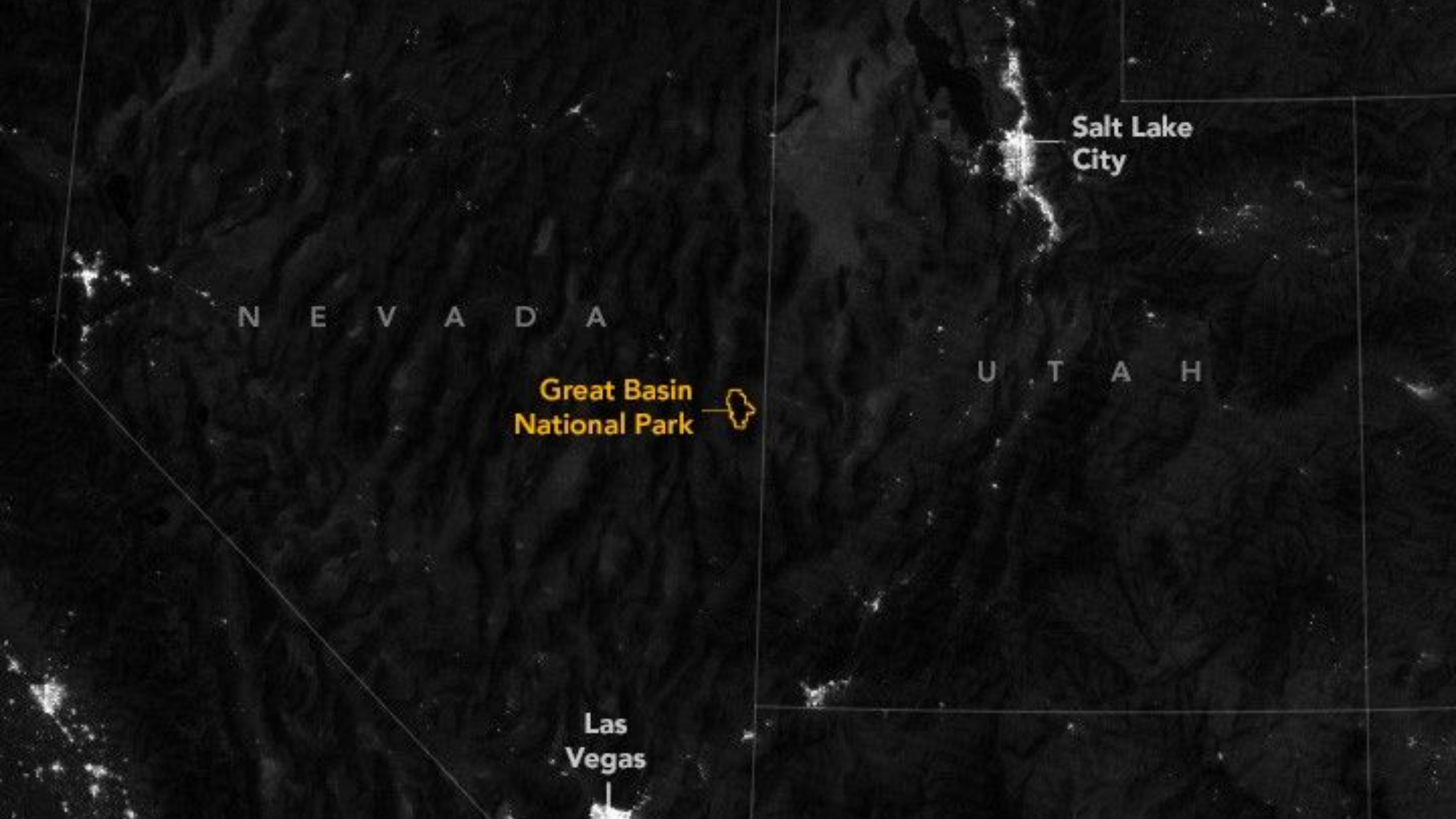
This image of Great Basin National Park, one of the darkest places in the U.S., was taken in 2025 by the VIIRS (Visible Infrared Imaging Radiometer Suite) on the Suomi NPP satellite. VIIRS can detect signals such as auroras, city lights and reflected moonlight. You can see the contrast between the dark sky zone and major light sources like Las Vegas and Salt Lake City. (Image credit: NASA)
To bridge that gap, Smith and his colleagues focused on the Colorado Plateau, a rugged region spanning Utah, Arizona, Colorado and New Mexico that contains one of the world's highest concentrations of "gold-tier" dark-sky sites, a designation that signifies the darkest and clearest night skies on Earth.
Over 82 nights in April, May, September and October, researchers interviewed visitors after dusk at campgrounds, scenic overlooks and parking areas. In total, they surveyed 634 travelers across nine destinations, including Arches, Bryce Canyon, Canyonlands and Natural Bridges National Monument, focusing on visitors whose trips depended specifically on high-quality night skies, the study notes.
By pairing survey responses with satellite measurements of nighttime brightness and local atmospheric conditions — including humidity, moonlight and airborne particles, all of which affect sky visibility — the team found a consistent preference for darker skies and a willingness to pay more for them.
The highest projected welfare losses, the researchers found, were heavily concentrated at premier destinations, led by the Grand Canyon and Zion national parks. Smaller or more remote parks showed comparatively modest total losses, a result driven by fewer visitors rather than an absence of dark-sky value, the study notes.
The researchers suggest that extending this kind of monitoring across a full year and over multiple years could help treat the night sky not only as a scientific and cultural asset, but as a measurable economic asset whose value changes with lighting policy, development and conservation.
As cities expand and artificial light continues to spread, studies like this are reframing a question once largely confined to science as an economic one: what is a star-filled sky worth?
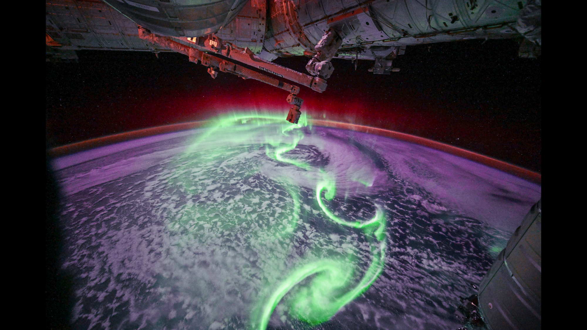
Auroras from space dazzle in this image captured from the International Space Station by ESA astronaut Sophie Adenot. (Image credit: ESA/NASA/S. Adenot)
If you've ever seen auroras in the night sky, then you are one of the lucky few who has enjoyed a view of one of nature's most colorful and spectacular phenomena. But for the very lucky, very few who've seen auroras from space, the view is on a whole other level!
What is it?
When charged particles streaming constantly from the sun, also known as the solar wind, reach Earth and interact with our atmosphere, it creates what we call auroras. Seeing these spectacular, colorful displays in the sky is on many people's bucket list, as auroras can light up the sky in a rainbow of colors. But this beautiful phenomenon happening in our atmosphere can also be seen from space.
European Space Agency astronaut Sophie Adenot, who is currently aboard the International Space Station as part of the εpsilon mission, spotted the aurora australis, or auroras over the Southern Hemisphere. (Lights in the Northern Hemisphere are known as the aurora borealis.)
And the image she captured of the moment really speaks for itself. Neon green swirls look truly otherworldly against a haze of bright purple blanketing Earth, which also seems enveloped in a ruby red glow. The reddish glow of the auroras can even be seen against the outside of the space station in this photograph.
Why is it incredible?
While her photograph speaks for itself, Adenot actually shared her own thoughts on the view via social media. One incredible thing about human spaceflight in the modern world is that, even from an orbiting laboratory, astronauts can share their experiences with the world in real time.
"Day 127, orbit 1968 — That aurora was absolutely spectacular… shimmering and dancing beneath us, stretching as far as the eye could see, and so intense it lit up the Station in shades of green," Adenot said. "We’ve seen several since the beginning of the mission, but this one was on a completely different level — far too bright for my usual aurora camera settings. Moments like these never get old up here; the whole crew suddenly find themselves vying for a good spot at a window!"
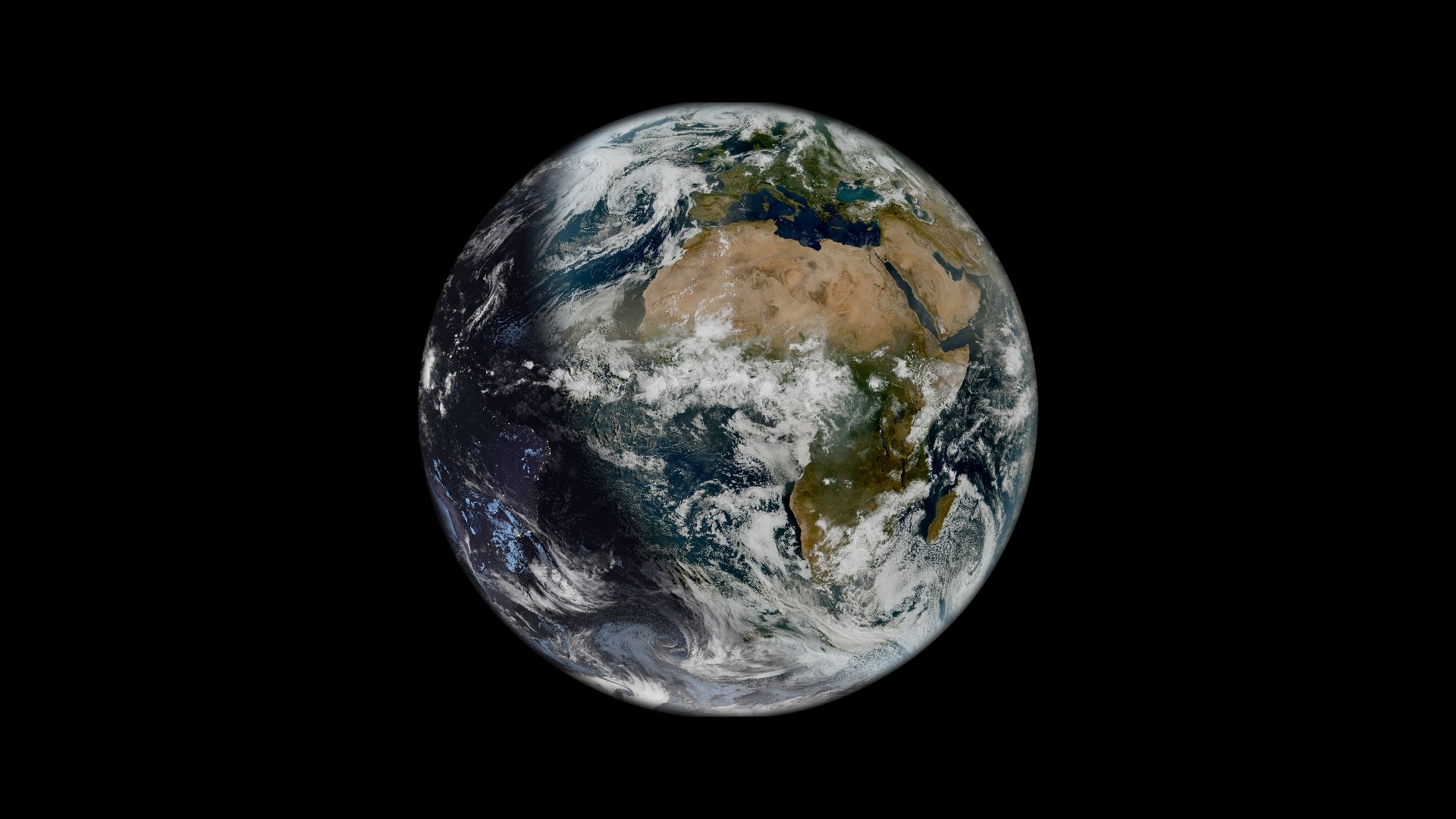
The solstice can even be seen from space in this new image from the Meteosat Third Generation (MTG) mission. (Image credit: ESA/Eumetsat)
Twice each year, we celebrate what we call a solstice when Earth is at its maximum tilt toward or away from the sun. And during this June's summer solstice, a European weather satellite managed to capture a striking image of the celestial moment from space.
What is it?
This image of the solstice was captured on June 21 by the European Space Agency's (ESA) Meteosat Third Generation (MTG) mission. This is a fleet of Earth-monitoring satellites that capture images of our home planet to support weather monitoring over Europe, Africa and regions of the Atlantic and Indian Oceans. The first Meteosat satellite launched in 1977 as ESA's first Earth-observing mission, and to date, there have been 11 satellites launched as part of this series.
In this image, the first of the third generation of Meteosat satellites, MTG-I1, captured an image of Earth just six minutes after we passed the moment of summer solstice, according to ESA. This image shows clearly Earth's "terminator line," or the fuzzy "line" that divides nighttime and daytime on a planet.
Why is it incredible?
On the day of a solstice when Earth is at its maximum tilt, there is almost exactly the same amount of daytime as there is nighttime. In the northern hemisphere, the June solstice marks the longest day of the year, or the day with the most sunlight. And, in the southern hemisphere, the June solstice marks the shortest day of the year.
In June, those in the northern hemisphere celebrate their extra hours of sunlight before the days start getting shorter again. Historically, solstices have been celebrated around the world, folded into cultural traditions and practices. As humans invented agriculture, and our food systems rely on things like available sunlight, it makes sense that throughout time, the changing duration of sunlight would be tightly intertwined with all aspects of our day-to-day lives.