
Shoebox-sized ‘detector satellites’ could sniff out a nuclear bomb in space

A constellation of cubesats fitted with special detectors could sniff out nuclear weapons hidden on satellites launched by adversary nations, according to a new study.

In 2024, rumors began to swirl in military circles that Russia might be developing a space-borne nuclear weapon. At that time, two years into the war in Ukraine, Russia was well aware of how big a lifeline SpaceX's Starlink broadband constellation had been for the Ukrainians. Starlink has not only provided connectivity to ravaged cities and frontline troops but also helped Ukrainians counter-attack the Russian invaders more effectively.

Drones fitted with Starlink terminals could reach much more distant targets than those controlled via conventional radio links. As the Starlink signal is almost impossible to disrupt by jamming, the idea that Russia might consider wiping the megaconstellation out by brute force didn't seem impossible.

Researchers know that a nuclear detonation in orbit would flood the space around Earth with fast, energetic electrons. These particles would destroy most unhardened satellites within range, which would extend to orbits even hundreds of miles away from the explosion.

"It would make the low Earth orbit and very low Earth orbit — where the Starlink satellites are, where many reconnaissance and communications satellites are, and where the International Space Station is — uninhabitable for a long period of time," Areg Danagoulian, an associate professor of nuclear science and engineering at the Massachusetts Institute of Technology and the author of the new paper describing the proposed detection method, told Space.com.

"We would essentially not only lose the satellites in those orbits, we would lose those orbits for a few years," he added.

Humankind has already seen the effects of a nuclear explosion in space. In 1962, the U.S. detonated a 1.4-megaton hydrogen bomb at an altitude of 240 miles (400 kilometers) above the Pacific Ocean. Radiation from the explosion, known as the Starfish Prime test, destroyed one-third of all satellites in orbit at that time. Admittedly, there weren't that many up there — fewer than 100 — but the impact was far-reaching.

Today, a nuclear detonation in space would be a catastrophe. It would knock out internet-beaming constellations such as Starlink and Amazon Leo, as well as hundreds of Earth-observing satellites that keep an eye on the activity of adversary nations, the changing climate and areas struck by natural disasters.
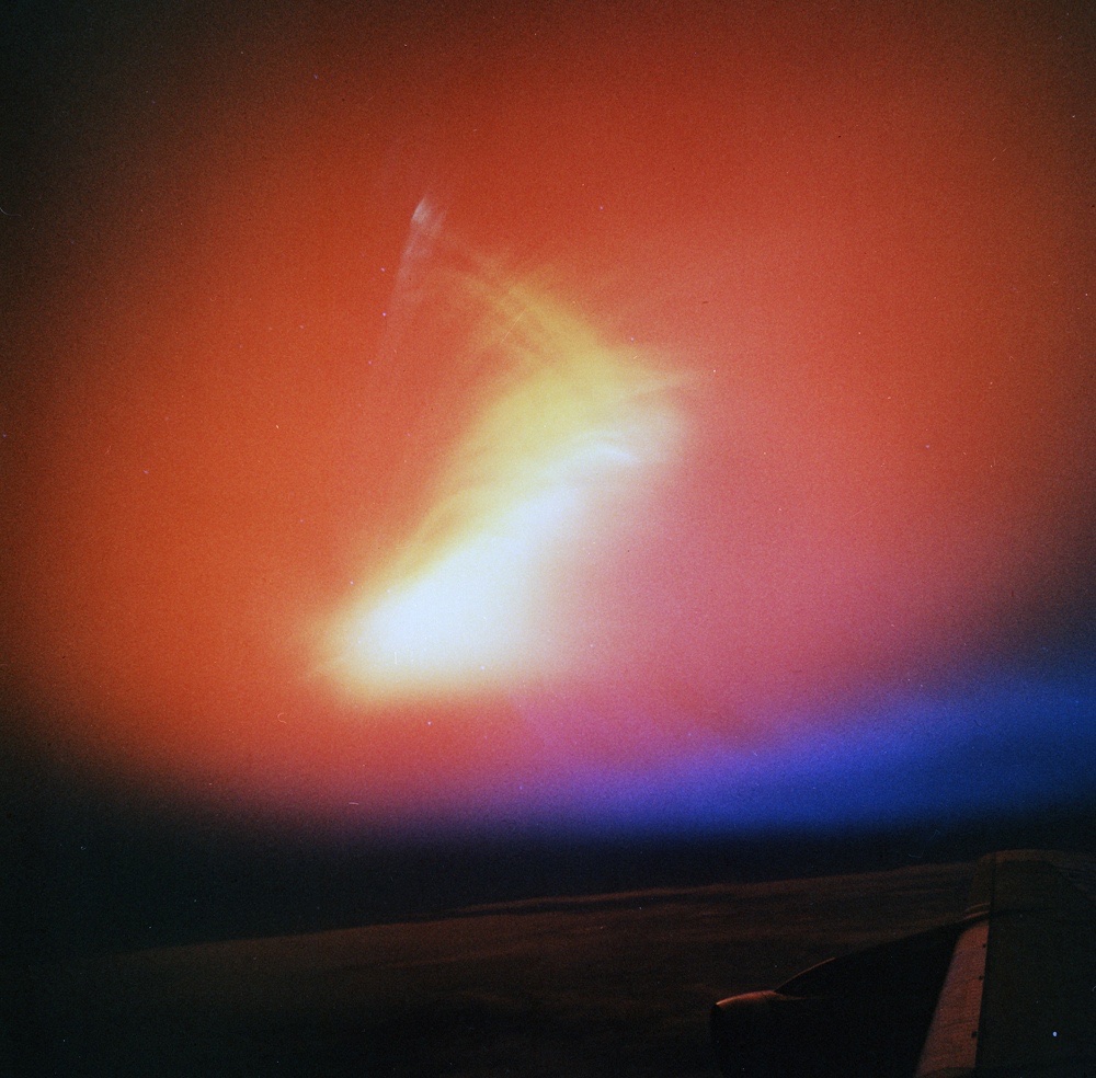
Photograph of an aurora caused by the Starfish Prime high-altitude nuclear test explosion on July 9, 1962. (Image credit: Public Domain)

No reliable way currently exists to detect and defuse a nuclear bomb in space. Danagoulian proposes a constellation of small "9U" cubesats, each one about the size of a large shoebox and each carrying a special detector capable of sensing radiation emitted by unexploded nulear bombs.

He explores a scenario in which Russia launches a suspected space nuke into an orbit with an altitude of 1,200 miles (2,000 km). That number is not random. In 2022, Russia's Kosmos 2553 satellite, orbiting at that exact altitude, triggered suspicions it might be testing components for a future orbital nuclear weapon.

Russia claims the satellite just observes Earth. At that altitude, the satellite passes through the Van Allen belt, a region of intense cosmic radiation trapped by Earth's magnetic field. Most of the belt stretches between altitudes of around 600 miles (1,000 km) to tens of thousands of miles, but in some areas the radiation can reach much closer to Earth's surface.

The interaction between the fissile material inside the nuke and the energetic particles from the radiation belt would create distinct signatures, Danagoulian said, which could help confirm whether a suspicious satellite carries a nuke or not.

"The thermonuclear weapon would contain a significant amount of uranium," Danagoulian said. "The high-energy protons [in the uranium] would break up when another proton is coming in and shred the nuclei. That would knock out a large number of neutrons. This interaction turns that device into a very intense neutron source that otherwise would not be there."

The process is known as proton-induced neutron spallation, which essentially means the ejection of fragments from material triggered by impacts of protons.
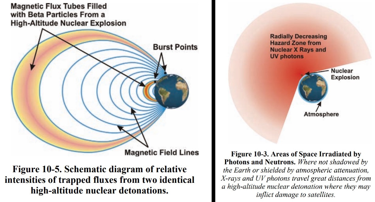
Two figures from the 2008 "Report of the Commission to Assess the Threat to the United States from Electromagnetic Pulse (EMP) Attack" illustrating the effects of a high-altitude nuclear explosion in Earth's atmosphere and how Earth's natural radiation belts can trap radiation released by nuclear detonations in or near space. (Image credit: U.S. Dept. of Defense)

The detector satellite Danagoulian proposes would have to be able to get quite close to the suspect spacecraft — a few kilometers. The inspector spacecraft would carry a sensor combining two types of detectors. At the heart of the device is a neutron scintillator, which detects all incoming neutrons and protons. Around it is a "cage of diamond" detector that detects only neutrons — not protons. Such a set-up helps filter out the particles present in the environment naturally, said Danagoulian. In addition, by using two "planes of neutron detectors," the sensor can determine the direction from which the neutrons arrived.

"If the external diamond detector triggers and gives a signal, you can ignore the particle, because it's most likely a proton and not a neutron," said Danagoulian. "Once you identify those neutrons, by having those two detections, you can back project and find out where the neutron came from."

Danagoulian says such a nuke sniffer would have to be launched into an orbit aligned with that of the suspicious satellite and creep up as close as 2.5 miles (4 km) from it. It would then take about a week to gather enough measurements to confirm whether the object is hiding a nuke or not. A constellation of 10 such satellites could reduce the process to mere hours, Danagoulian said.

If a nuke were detected, the military could then try to jam the satellite's communications link from the ground, making it impossible for the adversary to remotely detonate the bomb. There is currently no technology available to safely defuse a nuclear weapon in space.

The United Nations Outer Space Treaty, which provides the legal foundation for humankind's use of outer space, bans the use of nuclear weapons in orbit. However, the treaty has no means to ensure compliance.

Other approaches to nuke detection in space have been explored, including maneuverable X-ray satellites, but those would be quite a bit more complex and expensive.

Danagoulian also suggests that high-grade radiation hardening could improve satellites' chances of surviving a nuclear winter in space.

The paper was published online in the journal Nature today (July 8).

‘This is the future of spatial intelligence’: Vantor unveils stunning 3D satellite views of Earth (photos)

The American Earth-observation company Vantor maps Earth from space in 3D. The images are available in near-real time, revealing immediate effects of natural disasters and armed conflict. What is more, the images are also absolutely stunning.

Vantor, which operates a fleet of 10 satellites that image the surface of the planet with a resolution of 12 inches (30 centimetres), released the first set of its 3D shots from space on July 1. The images capture a variety of targets, all in amazing detail.

For example, there are shots of iconic landmarks in Paris; the Eiffel Tower, the Arc de Triomphe and the modernist quarter La Défense emerge in the images as if seen from a landing plane. Other image sets track the progress of ship-building activity at China's Yulin Naval Base and decreasing water levels at Arizona's Hoover Dam.

satellite photo showing the eiffel tower, with a river just to its left

The Eiffel Tower, captured by a satellite operated by the Earth-observation company Vantor. (Image credit: Vantor)

the standard resolution of 20 inches (50 cm) with an accuracy of 13 feet (4 meters) in all directions, and the HD version with a 6-inch (15 cm) resolution and a 10-foot (3 m) accuracy in all dimensions.

The 3D views are created by combining multiple satellite images taken from different angles and are updated every 24 hours or less to track even the most rapidly occurring changes in the landscape. The images form a basis for 3D maps that could, for example, help autonomous drones navigate in areas hit by GPS jamming.

The satellite fleet's ability to rapidly update the imagery is a unique feature that was impossible to achieve by other 3D mapping technologies. Most commonly, mapmakers and organizations would have to conduct costly imaging campaigns from aboard aircraft or using remotely controlled drones. Neither of these approaches, however, allows such regular and frequent revisits, according to Vantor. On top of that, drones and planes may not be able to safely access and map areas controlled by unfriendly nations.

satellite photo of a large arch, which is surrounded by diagonal tree-lined streets leading to it

The Arc de Triomphe in Paris, captured by a satellite operated by the Earth-observation company Vantor. (Image credit: Vantor)

"From command and control to autonomous systems operating in GPS-denied environments, many of today's most complex missions require current, accurate 3D terrain," Peter Wilczynski, chief product officer at Vantor, said in a statement.

"With WorldView 3D, customers can update the specific areas they care about, including remote and contested areas where traditional aircraft collection is limited, with unmatched speed and scale," Wilczynski added. "This is the future of spatial intelligence."

The US Space Force just got a new electromagnetic weapon to jam adversary satellites

The U.S. Space Force has acquired one of its first publicly acknowledged offensive weapons, one that can blast adversary satellites with beams of electromagnetic radiation to disrupt their signals without physically damaging them.

The system, known as Meadowlands, was developed by L3 Harris. It is an electromagnetic warfare system, meaning it is designed to disrupt, deny or degrade an adversary's use of the electromagnetic spectrum  — such as radio waves, for example  — rendering their satellites effectively silent, unable to communicate or share data with forces on the ground. These are "reversible effects," meaning they don't permanently destroy satellites but instead jam or interfere with signals being transmitted to or from them.

Or, as the Space Force puts it, Meadowlands provides the U.S. military with a "robust toolkit for spectrum dominance," according to a statement. Based on the few publicly available photos shared by the U.S. Space Force, Meadowlands appears to consist of an antenna dish mounted to a wheeled trailer, which presumably could allow it to be transported either by ground or a large cargo aircraft. This would allow it to be deployed in areas where adversary satellites might be stationed overhead.

According to available budget documentation, Space Force requested nearly $460 million in Fiscal Year 2027 to develop Meadowlands and the support and training needed to field it.

Space Force leadership has repeatedly stated that these types of systems are key to the U.S. military's current emphasis on space-based warfare. "Continued U.S. Space Force investment in electromagnetic warfare systems, software, and advanced training is essential to modern warfare," said U.S. Space Force Col. Angelo Fernandez, commander of Mission Delta 3 – Space Electromagnetic Warfare, a unit tasked specifically with operating systems such as Meadowlands.

In the same statement, the Space Force said that these types of capabilities were central to the success of Operation Midnight Hammer, a June 2025 offensive in which the U.S. military attacked nuclear sites in Iran.

During that conflict, "electromagnetic warfare professionals successfully created a silence zone to ensure secure bomber ingress and egress, effectively halting adversary communications to provide vital indications and warnings," Space Force said in the statement.

Gen. Chance Saltzman, the service's current Chief of Space Operations, cited how Space Force personnel employed the same types of capabilities during the ongoing conflict with Iran in a keynote speech at the Space Foundation's annual Space Symposium in April 2026.

"On day one of Operation Epic Fury, one of these specialists led the planning and execution of high-tempo space electronic warfare fires for U.S. Central Command," Saltzman said. "That's what it means to be a Guardian in today's Space Force."

The service has been procuring these types of systems and training its personnel in what it calls orbital warfare since the Space Force was created back in 2019. Because satellite surveillance and communication systems are so vital to the battlefields of today, the ability to disrupt an adversary's use of space is a highly sought-after one by militaries worldwide.

Europe’s deadly heat wave seen from space | Space photo of the day for June 30, 2026

Land surface temperature data captured by Europe's Copernicus Sentinel-3 mission on Wednesday, June 23, 2026. The data were captured in the late morning, local time. (Image credit: contains modified Copernicus Sentinel data (2026), processed by ESA)

Over 1,300 deaths have been attributed to a heat wave that swept across Europe and broke temperature records earlier this month.

From its perch in sun-synchronous low Earth orbit, Europe's Sentinel-3 satellite captured data that helps visualize the heat wave and aids researchers in understanding both the causes and effects of the atmospheric phenomena that led to these soaring temperatures.

What is it?

In this image from the European Space Agency (ESA), land surface temperatures are depicted on a scale that depicts hotter temperatures as red and violet. On the date this image was taken, June 23, France recorded its hottest June day ever, according to ESA.

The Sentinel-3 satellite detected surface temperatures as high as 131 degrees Fahrenheit (55 degrees Celsius) in parts of central Spain, western France and northern Africa, while Madrid saw 118 degrees F (48 degrees C), and surface temperatures in Rome reached 111 degrees F (44 degrees C).

Why is it incredible?

Temperatures this high were unprecedented across of much of Europe. Authorities with the World Health Organization (WHO) estimate that over 1,300 deaths may be linked to the heat wave. And things may get worse for the continent.

"Europe is the fastest-warming continent on Earth, heating at twice the global average," WHO chief Tedros Adhanom Ghebreyesus posted on X.

By providing real-time temperature data over both water and land using its Sea and Land Surface Temperature Radiometer instrument, the Sentinel-3 satellite is providing unprecedented data about these extreme weather events and how they affect populations.